Last Updated on December 22, 2023 by PowersToTravel
We are snowbirds with a condo in Isabela Puerto Rico, just west of Jobos Beach, and I maintain the list called “Top Local, and Not-So-Local Things to Do in Isabela Puerto Rico“. It’s a great soup-to-nuts list of everything in the local area that a guest might need. I created it when we hosted Airbnb guests in our condo. We don’t rent our condo out anymore because we fixed it up so nicely we don’t want to share!
However, we host family and friends each year and plan where to take them and what to do. After five years of hosting, I thought I’d share with you our favorite itinerary.
Day 1 – Jobos Beach, Pozo de Jacinto, Paseo Tablado, Tunel de Guajataca, Cara del Indio and Isabela Town Square
Jobos Beach
If you live near Jobos, you have to first take your guests there. We walk fifteen minutes down the beach from Haudimar Beach Apartments to the Jobos Beach area which is full of restaurants, surfers and families lounging in the shallow waters. It’s a great introduction to a special local Puerto Rico beach vibe. If you are able to walk to the beach it’s best. If you have to drive, then you’ll find the road on either side quickly becomes crammed with parked cars. Our favorite restaurant, Uma’s, does have a parking lot, but good luck finding a spot there!
Why is Uma’s our favorite? It has good food and good Puerto Rican favorites too. Like all the restaurants at Jobos, it is open air and has direct access from the beach.
We’ve actually seen turtles in the waves as they approach the shore, west of the restaurants. This happens in the winter.
There are no lifeguards at the beach, and it is known to have a very strong undertow, especially to the east, near the rocks. It is heaven for surfers, but remember that swimmers are not surfers. Stay in the shallows with the rest of the “swimmers” and if you find yourself being pulled out, don’t hesitate to call for help from the surfers.
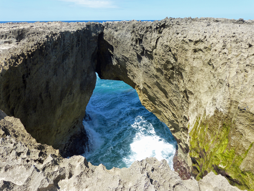
Pozo de Jacinto
We always make sure we carry our shoes or sandals when we walk to Jobos because Jobos directly leads to the Pozo de Jacinto area and the Paseo Tablado. If you walk along the beach east almost as far as you can go, and then head away from the water, you find the path to the Pozo. Pozo means “well” in Spanish and the Pozo is an open hole in the volcanic rock into which the waves come crashing surging skywards, depending on the tide and winds. It’s located near the gazebo which is on the path.
The area around the Pozo is volcanic rock and extremely sharp. It is not the place to walk your grandmother! We were there once when a middle-aged woman tripped, fell and gashed her head open. It was extremely nasty. I’ve been to the edge of the Pozo once, and that’s enough for me! Stay on the path, don’t go out on the volcanic rock. Your grandmother will be happy with that walk!
From the Pozo area you then head eastwards, and walk along the Paseo Tablado, the boardwalk. It is a beautiful walk over (not on) the sand dunes. Even though it is flat boards, the wood gets extremely hot in the sun and you need to make sure you wear your sandals or shoes. Look down and you may find iguanas fighting for territory. Be sure to dodge the electric scooters and tourists that zip on the Paseo Tablado. The Paseo Tablado continues to the Isla Bela Apartments, but the walking path continues further, if you are so inclined.
We head home, either to our car at Jobos, or all the way home to the apartment, then continue our day driving.

Tunel de Guajataca
We drive east along the beach, up through the town of Isabela and out briefly on Rt 2. Shortly you will find the turn-off for the Guajataca Tunnel.
The parking lot there is large and faces a beautiful, non-swimmable beach. Vendors sell fruit juices and souvenirs. There’s a food truck too. Artists have been hired to paint beautiful tropical murals on the ramshackled buildings that lead to the tunnel. It’s definitely a fun photo-opportunity.
Continue walking through the tunnel and you will find yourself on a gravel path with stunning views of the jagged rocks and waves. The path leads directly to the beach which is also strewn with boulders. Check out the crabs that skitter about in the shadows below the boulders. I don’t think I’ve ever seen anyone swim here – it looks dangerous.

Cara del Indio / Monumento al Cacique Mabodamaca
That’s a handful to try to say. Usually I simply refer to it as “La Cara” (the face). It is a huge face of a Taino (native Indian) carved into the cliff at junction of Rt 2 and Rt 113 on the very eastern end of Isabela. As you leave Guajataca and get onto Rt 2 heading west, it is at the next exit. I mean, immediately at the next exit – it is part of the exit! You can park your car after the souvenir stand. Be careful as you cross the road for the best pictures since cars are exiting the highway quickly.
There’s a man at the souvenir shop with a cockatoo and parrot you can pose with, for a small price on Fridays, Saturdays and Sundays.
Depending on which mapping tool you are using, it might be called “Homage to the Natives.”
Then you get back in your car, and continue driving west on Rt 113 to downtown Isabela.

Downtown Isabela
Isabela is one of the more beautiful downtowns in Puerto Rico. It isn’t as historic as some, but has been beautifully designed and maintained and has some interesting public artwork in the plaza. Talk about a typical Puerto Rican plaza – this is the place where the seniors meet to sit under the graceful tropical trees and play dominos. It’s also the location of many town festivals and fairs.
From downtown Isabela it’s a ten minute drive back to the Jobos area, and everyone is anxious to relax and perhaps take a swim in the pool!
Day 1 Map
Day 2 – El Faro Los Morillos and a late lunch at Joyuda
This day involves a long drive directly south to the southwest tip of Puerto Rico. The drive seems long because about half of it is on Rt 2 with its stop-lights and shopping traffic. You’ll want to time it so that you don’t hit Mayaguez during rush hour. Mayaguez is 45 minutes south of Isabela. We usually get a 8:30am start so that we get through Mayaguez after the traffic, and arrive at Los Morillos with time to visit before a late lunch.
As you head south of Mayaguez you’ll see that the terrain gets dryer and dryer. It becomes almost desert-like in areas. The area around the lighthouse offers little shade, so you’ll not want to be doing the hike in the high heat AFTER lunch.
After you pass Cabo Rojo and shortly before the lighthouse, you’ll see the Las Salinas (salt flats) on your left.
Las Salinas
You can pull the car over near a fence/gate and walk out to see and take pictures of the pink flats.

There used to be road access all the way to the lighthouse parking lot, from which it was about a .4-mile walk on a rutted road up to the lighthouse and views. The road has been closed since Hurricane Fiona, so you must park at the blocked gate (just north of the place marked “Puente Antiguo” on Google maps) and walk 1.7 miles up to the lighthouse. Grab a couple of water bottles a person, and some granola bars. It’s a hot hike, but on a former road, so not difficult to navigate.
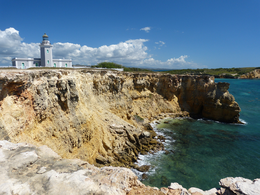
As you stand facing the sea in front of the lighthouse, if you turn to the right (west), you’ll see a path heading along (but not too close to) the cliff-top. Continue walking on that path. There are beautiful views of the sea and a stone arch over the water. Eventually you’ll come join back with the road to the parking lot.
Be very careful and do not approach the edge. Erosion has undercut the rock and what appears to be stable is not necessarily so. Many people have fallen to the death here.
You may spend about an hour and a half here (hike up the road to the lighthouse, around and about, and hike back along the sea), depending on how fast you walk and how many pictures you stop to take.
From the lighthouse gate north to Joyuda it’s about a 40 minute drive.
Joyuda Restaurants
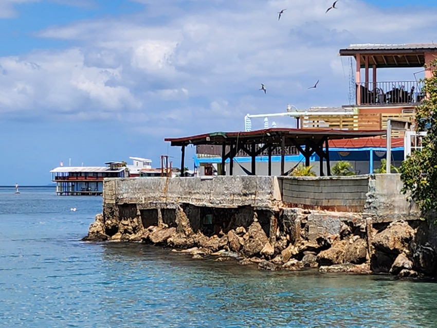
Joyuda is a small town along the southwest coast of Puerto Rico. It is quite a contrast to Isabela in that there are no waves, just water lapping at the rock walls. There are many restaurants to choose from. We’ve liked El Bohio (for its large balcony over the water) and El Gato Negro (our first one). Tarpon, huge fish, swim around under the piers waiting for you to feed them. The problem is, the food is too good to give to the fishes!

At this point, you’ll probably get glad to go home. But the driver has to drive another hour, hopefully not through the Mayaguez rush-hour traffic!
Day 2 Map
Day 3 – Crash Boat Beach and Relaxation

You, or your guests, have, after all, come to Puerto Rico to enjoy the water! The closest and best swimming and socializing beach is Crash Boat Beach in Aguadilla. Aguadilla is great because it is at the very northwest tip of the island. The waves at the beaches which run down from that tip are generally calmer than Isabela, where all the beaches face north.
Crash Boat is a very popular beach. Unlike Jobos, there actually is a parking lot, but it does fill up. You have to pay for parking, as well. In the late winter, we were able to find a spot in the afternoon and enjoyed a great afternoon at the beach. Our neighbors tell us that in the summer the clouds and storms roll in about noon, and everyone arrives at the beach very early and leaves when the storms arrive, and the parking lot fills up quickly.
Crash Boat offers a lot: A lot of sand, beach chairs and umbrellas to rent, ski-doos to ride, snorkeling under the pier, jumping from the pier, vendors selling pinchoes, fresh pineapples and other treats.
What Crash Boat does not have is important for you to know: Crash Boat does not have changing rooms or even bathrooms. It used to, before Hurricane Maria, but not since. Hopefully the town will soon remedy this.
Map Day 3
Day 4 – Rincon and the Falls at Gozalandia
Wear your bathing suit under your clothes, and bring a towel.
Rincon
Rincon is an entirely different eco-system when compared to Isabela. Rincon is located on a large peninsula extending into the Straits of Mona on the West Coast. While some of Rincon is at the sea’s edge, the majority of people live in houses clinging to the hills above the town.
A quick drive into the hills tell you that Puerto Rico isn’t just beaches – it is Mountains. Windy, narrow roads snake up and around. It is important to drive slowly and be aware that around the next bend may be a vehicle traveling right in the center of the road! If you suffer from car-sickness, Rincon is not your ideal destination. The views are beautiful, but at a cost! If you suffer from car-sickness, then stick to the seacoast (Rt 2 South to 302 or 115 West) and you’ll still have a lot to see in Rincon.
Rincon is also renown for its surfing beaches. We enjoy going through town and then north to El Faro de Rincon, the lighthouse park. The lighthouse is set on a cliff with great views of Domes Beach and the surfers.
Above the lighthouse, perched on a hillside is The Beach House, one of our favorite restaurants. It makes a great lunch stop with beautiful sea views.
You might even enjoy a swim in Rincon, beach depending on the season and wave action.
From Rincon, we head back north, but take a detour from Rt 2 to go to Gozalandia Falls.
Gozalandia Falls
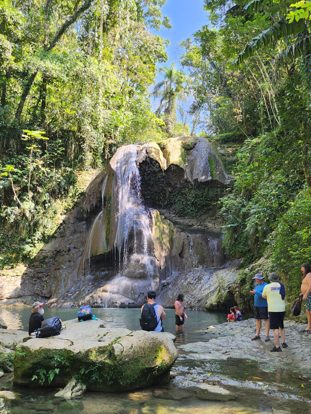
Gozalandia Falls is located in the mountains to the east of Rt 2, in San Sebastian. It’s called Cascada Gozalandia on Google Maps. It is a popular place to swim in a waterfall. Actually there are two waterfalls, so you won’t want to miss out on one. Which one is best? You’ll have to decide.
The path from the parking lot to the gorge and the waterfalls is paved, so sneakers or sandals will do just fine. You’ll need to be able to climb many steps down (and then up again) to reach the lower (first) falls. The path will let you out on the wet river rocks, so you’ll want to be wearing flip-flops or water sandals at that point. The water is COLD! It gets warmer and warmer as the season progresses. But in January, February and March we have never dared to get in, although there are many who do! The picture above was taken in February.
At the second waterfall, which is reached by an uphill cement path, you’ll have to be able to climb down some significant rocks to reach the water. This pool is somewhat larger than the first one.

You’ll want to have brought your towel with you. At least here there are bathrooms! They are up near the bar at the parking lot, so use them first before heading to the waterfalls!
Now to get home, you have two choices. You can drive back the way you came, along Route 111 West to Route 2 North. Google says that it takes about 53 minutes. The route is a straight shot, if uninspiring.
The shorter route is over the mountains. Once again, if you have someone along who gets carsick, they will get carsick. It is an iconic Puerto Rican mountain drive, and one that every visitor to Puerto Rico should experience, however, it can be traumatic if you have a tendency to suffer carsickness.
Day 5, 6 and 7 – Swim, Hike, Snorkel, Horseback Ride, Sunbathe
It all depends on your interests. The itinerary for days 1 to 4 doesn’t allow you much time to enjoy the beach, so you’ll want to watch the weather and wave forecasts, and perhaps spread out those four busy days and intersperse them with some beach time.
If you aren’t into laying on a beach, there are plenty of other activities on my Top Local and Not-so-Local Things to Do in Isabela. We can highly recommend the following:
- Tropical Trail Rides horseback riding on the beach west of Shacks Beach
- Snorkeling at Shacks Beach – you’ll first have to buy snorkels, or rent. We buy our gear at the Walmart. First check out the tides – we find it is best to go mid-tide. Too low and you’ll scrape the rocks in the lagoon area. Too high and the wave action which is kept at bay by the outer reef will wash over the reef and make the lagoon area too turbulent.
- Hike to Survival Beach – a not-so-easy hike along the side of the hill at the very northwest tip of Aguadilla. Leaves from the east end of the “Surfer’s Beach” parking lot. Definitely wear sneakers or hiking shoes, not flip-flops – the path is more a goat-path than a people-path, and more up-and-down than flat, and definitely more tree-roots than flat. Carry plenty of water and granola bars and juice. The hike offers stunning seacoast views. You’ll get out to the beach, and at the area before the climb over the mountain begins you’ll have no cell service.
- Bike Trail – check out the 6 mile Isabela bike trail. Rent scooters, or eBikes or bikes.
Last but not least, you could buy a condo or home while you are here, and become snowbirds, or virtual commuters yourselves!