Last Updated on April 28, 2023 by PowersToTravel
Back to “Two Weeks in Norway – With a Svalbard Add-on – Days 1 to 4”
Day 5 – Sogndal to Stryn
Urnes Stave Church

If two stave churches weren’t enough, today we would see one more – the UNESCO World Heritage site Urnes Stave Church. Urnes stands out for several reasons: it is the oldest still standing stave church, built in 1130, it has an unusual bas-relief carving in Celtic style on the exterior, and is situated in a very picturesque location at the side of a fjord.
To get to the Urnes Stave Church we must take the Solvorn-Ornes ferry across the fjord. The website recommends arriving early since it is a first-come, first-served ferry that leaves only every hour or so.
Generally visitors to Urnes Stave Church arrive as foot passengers on the ferry, then walk 20 minutes UPHILL to the church. If the weather is good, it is a lovely walk through farm and countryside. If the weather is not, well, it’s the same for all of Norway when the weather is not – it’s wet and gray. But a word to the wise: don’t dawdle too much on the walk up because they time the guided tour of the church to the ferry arrival. If you arrive, walk briskly uphill you will find yourself on time for the tour. If you meander your way uphill you may be late for the interior and you wouldn’t want to miss it!
It is only open May through September.
Then you can take your time on the walk down, being aware of when the next ferry will take you back to Solvorn.
Fjaerland

Time for a quick stop at Fjaerland. Fjaerland is located on the western side of, wait for it… Fjaerlandsfjord! It is known as the “bokbyen”, or “book town.” It is contains several used book stores and little honor-based book stalls. Here is a picture of one, courtesy of Google Maps since I failed to take a picture when there.

I can remember visiting Fjaerland in 2006 and my father’s excitement to go to a used book town. It wasn’t until he was browsing the stalls that he realized he couldn’t read them, since they were in Norwegian! For this trip, it simply made a great photo-stop, sadly under gray skies.
Fjaerland Glacier and Climate-Change Museum

The reason for our Fjaerland destination was the Norsk Bremuseum (glacier ice museum) located at the head of the Fjaerlandfjord, and its adjacent Boyabreen Glacier. The museum is an excellent break in the travel and offers a great fifteen minute movie of a helicopter ride to and ski down the glacier. (I get motion sickness, and this movie was, as I must say, true to life!). Food is also available, which is always welcome, especially after motion-sickness during the movie!
Why the best picture from the museum is of me with an mammoth statue is beyond me.
Boyabreen Glacier

Just north of the Glacier Museum is the Boyabreen Glacier viewing area, with some distance views of the glaicer. It, itself is an arm of the Jostedalsbreen Glacier. I had taken the long hike with my parents in 2006 up to the face of another related glacier, the Brikdalsbreen Glacier, and had read that it was dramatically receeding. For this itinerary with Greg, since time was of the essence, I chose to do the stop-by on the road to view this arm. It certainly was less dramatic, however, what with the weather, it was certainly a better choice for the day. Sadly we saw no blue in the ice.
Stryn

As you can see, the weather deteriorated after our wonderful trip to Urnes Stave Church in the morning; we headed directly up to Stryn and our hotel, the Visnes Hotel. The Visnes Hotel is a traditional hotel dating back to 1850. It was a fine hotel, but we caught a cold that day (who says raindrops don’t cause colds!) and coughed and snuffled our way through the night. (Note: our trip occurred before COVID-19, so there were no serious worries about our miserable condition.)
Day 6 – Geiranger
We departed Stryn still under low gray clouds and still snuffling. Knowing what lay in front of us, since I’d been to Geiranger three times before, I was very disappointed. I wanted Greg to see it in all its splendor. The weather is one of the reasons I keep going back to certain countries like Norway. You would think that bad weather would drive me away, but on the contrary, I get a taste of what it is like in good weather and keep wanting more, in spite of its mountain ecosystem and tendency to attract precipitation.
For our drive today we would head east on Rt 15 in the direction of Grotli, then north on Rt 63 to Dalsnibba.
Dalsnibba

Dalsnibba is a mountain peak above Geiranger. It does require good weather for optimal views. Clearly we missed it this day. This picture shows the switchbacks on the road; we haven’t gotten terribly high at this point since we are still under the cloud level. It’s a well-paved road; you just have to go slowly, and watch out for buses. You can see how high the plateau is, in general, since the snow has not yet melted up here.
It wasn’t until we descended far down the mountain that we could see Geiranger
Geiranger
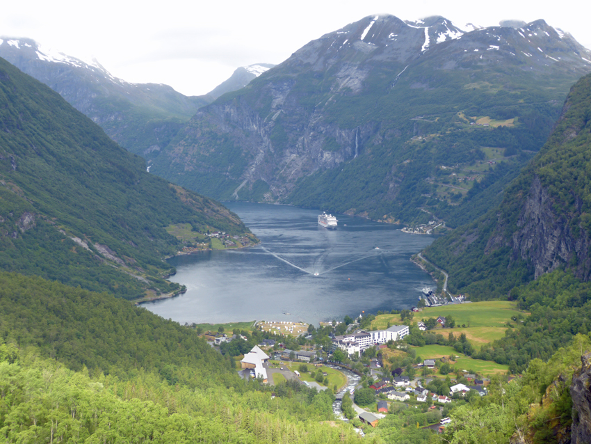
This is a view from “Flydalsjuvet”, a famous lookout above the town. Geiranger is a UNESCO World Heritage site and a busy port town. As you can see from the picture, cruise ships travel all the way from the Norwegian coastline, through the narrow fjords to reach Geiranger. As a cruise ship port, the population swells as the ships arrive. If quietude is important to you, I recommend checking out the cruise ship schedules to avoid the crush.
As a cruise ship port, you will find the ever-present troll to greet you. Greg here is offering him some of his Diet Dr. Pepper.

From the town center you can catch a fjord sightseeing boat which will take you out quite a distance into the fjord and show you some tremendous waterfalls. It has both indoor and outdoor seating which was appreciated with our colds and the weather. You can also take a RIB boat ride in Geiranger, but that doesn’t allow for good photography.

Hotel Utsikten
We stayed at Hotel Utsikten which is located a bit above of town, on the road to Dalsnibba that we had just descended. Why did we stay there? The views of Geiranger are tremendous if you choose the right room! I always book our hotel rooms well in advance of our trips so that even our hotel experiences are one-of-a-kind.
Day 7 – Geiranger to Trollstigen and arrival at the Trondheim Airport
Getting in and out of Geiranger is a first-class experience. On Day 6 we had experienced Dalsnibba and the Flydalsjuvet. Today we would experience “The Eagle Road” as we continued on Rt 63 north.
The Eagle Road

Tidy switchbacks lead from sea-level up the north side of Geirangerfjord, culminating in an expansive viewing platform. Luckily as we moved out early in the morning we encountered no slow-moving buses or any other obstacles.
Similar to the road entering Geirangerfjord from the west, this road to the north climbed to a snowy plateau. A short drive later we were down once again at sea level on the Eidsdal Ferry crossing Nordalsfjord to Linge.
Eidsdal Ferry

Including ferry rides when one is driving to a schedule and trying to make a flight can be a risky move. However, when there is no specific schedule to keep, other than a hotel room that night, a ferry makes for a great break in the rhythm: you must arrive at the ferry quai, line up and sit in your car or wander around for a while, realizing that you may or may not make it onto the next ferry due to tourist volume. Then you drive the car on the ferry and 1) stay in your car, 2) head to the often soul-less lounge, or 3) best option, hang on the upper rail outside the lounge with the wind in your hair. Then as you arrive, you hope and pray that you don’t end up departing the ferry behind a slow moving truck or RV. Relaxation and often a snack, followed by adventure. What more could you want?
North of the ferry quai the 63 road continues as it alternates between Snow Road and plunging towards fjords. First we encounter Gudbrandsjuvet.
Gudbrandsjuvet
A spectacular torrent of water in the spring and early summer, Gudbrandsjuvet has changed since our original encounter in 2001.

Then, a gentle path led from the road to the stone bridge, still there, and onward to the coffee and souvenir shop. Obviously the juvet, or gorge, is a popular bus-trip stop. Norway has significantly developed its tourist infrastructure over the past 20 years, as one might hope it would. Access is guaranteed via ramps; security is guaranteed via protective fences, and photography is guaranteed also through those fences, and with engineered viewpoints ending in glass. It was quite exciting to see what Norwegian dedication to access had delivered.

I missed the rustic quietude of the small time paths, and certainly the small-time crowds from 2001, but I also thought that some day I or a loved one might need that access and was grateful it is there.
The road continues on though a snow field to the top of Trollstigen.
Trollstigen

Continuing on that theme, this area used to just be a series of parking lots, with dangerous cross-overs to the giftshops on the west side of the road, and then another cross-over to the viewpoint on the east side of the road. It amounted to a lot of milling around on rough pavement.
Now there is a single parking lot with access to a relatively “new” visitor’s center built at the side of the river. Level paths lead from the visitor’s center towards the cantilevered viewpoint, which itself has been enhanced by a glass-ended platform:

After a long time viewing each tiny car as it slowly made its way up the mountain wall, we moved on ourselves, to become of of those tiny toy cars.
Once we descended the valley, we turned eastward on the E139 towards Dombas, and passed the Trollveggen.
Trollveggen

Trollveggen, or the “Troll’s Wall” is a craggy steep wall of rock. Perhaps some adventurers are there to climb, but we certainly are not. I took my picture and we continued our drive, which had now become a much faster road, parallel to the Rauma River. There are several scenic waterfalls along the road, but we stopped at only one. Was it Vermafossen, Kleivafossen or Slettafossen?
Waterfall

With Greg loving waterfalls as much as he does, it was hard not to stop at every one of them in Norway.
We continued on our drive to Dombas, then north to Trondheim on the E6, the roads getting straighter and flatter.
Where are the pictures of Trondheim? We took none. And why was that? We didn’t actually visit the city of Trondheim. Sadly there was no time in schedule for a short visit – we turned in our car at the Trondheim airport, checked in to the airport hotel. All to catch the morning train to Bodo.
It would have been possible to have driven into Trondheim itself, and stayed in a Trondheim hotel, and paid for taxi cabs to and fro, and left from the Trondheim central railway station. But I had been to Trondheim before and considered this particular loss a sacrifice to be made, to go north on this schedule with less stress for my driver.
Next “Two weeks in Norway – Trondheim to Tromso – Days 8 to 12”